|
| Namibia
is situated in the south-west of the African
continent and shares borders with Angola and
Zambia in the north, with Botswana in the
east |
|
and with Zimbabwe in the northeast.
In the south Namibia borders on South Africa and
the Atlantic Ocean stretches along the western coast.
Namibia has a surface area of 824 268 sq. km
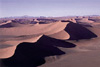
Namibia has a typical dry semi-desert climate. The
days are warm to hot, while nights are generally
cool. The summer season is from November until the
end of March and is also the main rainy season.
Average annual rainfalls vary from less than 50
mm along the coast to 350 mm in the central region
and 700 mm in the far north-eastern region.
Click
Here for the Lonely Planet Fact File on Namibia
|
|
|
|
Full
country name: Republic of Namibia
Area:
825,418 sq km
Population: 1.8
million
Capital city: Windhoek
(pop 161,000)
People: 86% African
(50% Owambo, 9% Kavango, 7% Herero, 7% Damara, 5%
Nama, 4% Caprivian, 3%
San, 2% Baster, 0.5% Tswana), 7.4% mixed, 6.6% white
Languages: English, Afrikaans,
German, Oshivambo, Herero, Nama
Religion:
Christian, Lutheran, native religions
Government:
Republic
President: Sam Nujoma
|
|
|
|